The “exciting new discovery” of a fault line running across the Saanich Peninsula can build on hazard models and remind residents to be ready for a different kind of earthquake.
Focus in the region is frequently on the hazard of mega-thrust earthquakes, said Theron Finley, an earthquake geologist and University of Victoria PhD candidate who is among the authors of the research published Dec. 6.
A secondary hazard lies in crustal faults, such as the newly identified XEOLXELEK-Elk Lake fault. While smaller they tend to be a lot shallower and in this case far closer to urban centres, posing a hazard.
“Our research group focuses on looking for faults of this nature and there’s not been a lot of work done on this,” Finley said.
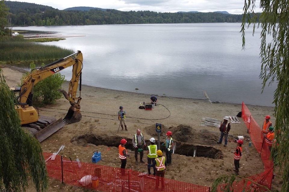
The report comes nearly two years after they physically investigated a segment of the fault with a trench near the shores of Elk Lake (XEOLXELEK).
First the team had to find the potential for a fault, primarily using lidar data.
The region isn’t unexposed to the low-flying helicopters sending laser pulses to map the landscape. After digitally removing trees and buildings they’re left with a detailed bare earth surface topographical map to scour for scarps – ruptures on the surface of the earth that could indicate a fault.
Once found, to study the earthquake history of the fault, the team used electrical resistivity surveying – using currents to map the distribution of sediment in the subsurface – and excavated a trench across the scarp to examine the sediment.
READ ALSO: Research off Vancouver Island looks to uncover what makes megathrust earthquakes tick
Like an archaeological dig but looking for ancient earthquakes, Theron explained.
The work revealed a single large earthquake, of magnitude 6.1 to 7.6, likely occurred there about 4,700 to 2,300 years ago.
“We obtain that by taking samples of organic material from sedimentary layers observed in the trench we dug and radiocarbon dating those,” he explained.
They also use measurements of how it moved and compare those to a catalogue of modern earthquake events to determine a range of magnitude.
“It’s an imprecise science because nothing in nature is perfect, that’s why we have a big range in estimate on what it potentially could have been,” Finley said.
The trench excavation happened in 2021 and the paper published just recently after rigorous peer review, but they’re far from finished.
“We do still have a lot of ongoing work on the Island looking for similar features elsewhere,” Finley said. “We suspect we will continue to find more as more lidar data is available.”
It’s an exciting new discovery that helps them better understand earthquake hazards in the region, said John Cassidy an earthquake seismologist with National Resources Canada. This work can only add to the understanding of earthquake potency and potential.
“We’re always trying to extend our earthquake history and that’s exactly what this study does,” he said. “It doesn’t tell us there will be another earthquake on this fault … but it does help us understand the history and it will help guide future research.”
READ ALSO: The day the Island shook: Vancouver Island rocked by earthquake 75 years ago today
Large crustal earthquakes have occurred here and are included in the hazard model already, Cassidy said, citing two in the magnitude 7 range – in December 1918 near the west coast of Vancouver Island and the June 1946 earthquake with a mid-Island epicentre.
“The trick is we don’t know exactly where they occur. When we find structures like this one it helps … it’s really exciting,” Cassidy said.
“This shouldn’t be frightening to people. It’s always been there and now we know about it and that there was an earthquake … it will help us to improve our hazard maps. It will help us to better understand and be better prepared.”
Previous modelling shows a future earthquake similar to the one the team documented could cause major damage in Greater Victoria.
“There have been loss estimates done for similar sort of event striking Victoria on a similar shallow fault like this,” Finley said.
A magnitude 7.3 on a fault like this in such close proximity to the city could cause about 1,000 deaths and 7,000 building collapses with more than $20 billion in economic hit.
READ ALSO: Vancouver Island slides west, tremors could signal tectonic shifting
“The likelihood of this happening in the next, for example, 100 years, is probably lower than the Cascadia thrust … but it does add one more fault that could cause damaging shaking to our portfolio of faults that could cause a problem,” he said. “I think we want to take it as a reminder to both increase our own personal resilience.”
In a place where we rarely feel any shaking, even with the myriad tiny earthquakes that constantly happen, it serves as another reminder to prepare or revisit things like earthquake plans and emergency preparedness kits.
“People forget. We see rushes of people to the emergency preparedness stores when there’s a small shake because people feel under-prepared. Hopefully even news of this discovery is motive for people to get out and prepared,” Finley said. “On a more systemic level we need to really be taking seriously the work required to strengthen our buildings and protect human life.”
Find the article here.