Victoria City Council has approved the Victoria West Neighbourhood Plan following a public hearing Thursday night.
Planning began in spring 2016 to revitalize and expand the Vic West neighbourhood, and an extensive project has been set out with short term plans, running from 2018-2020, and ongoing plans targeting the next 20-25 years.
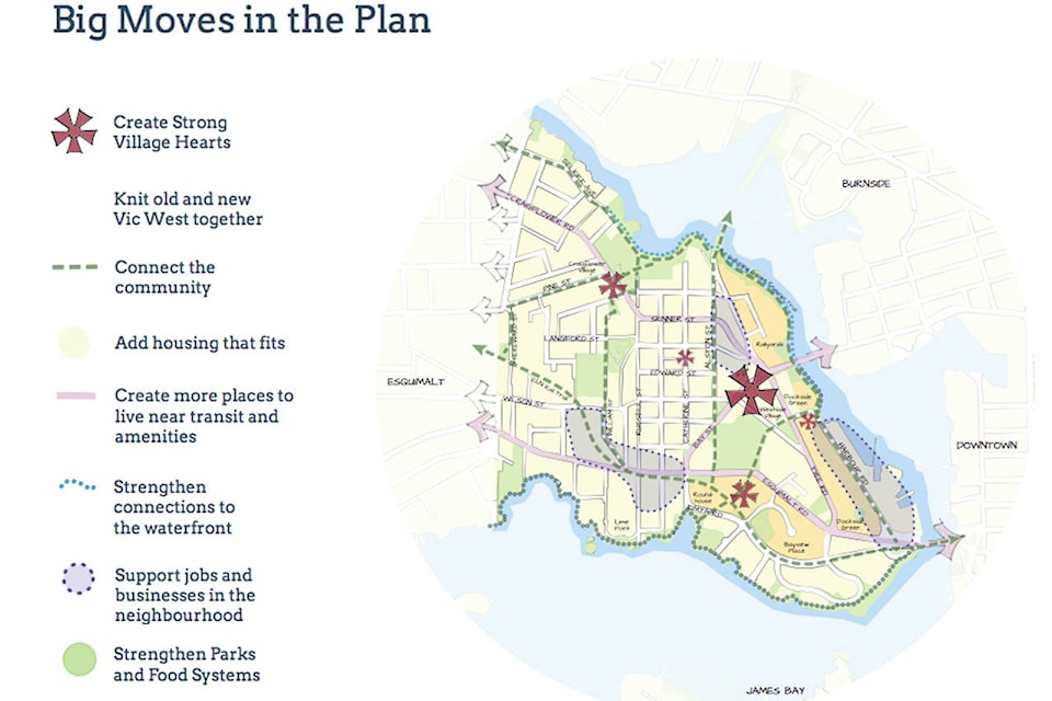
Senior Planner Kristina Bouris said after a lot of public feedback there were several priorities to address. These included affordable housing, creating active transportation routes, further establishing Westside Village and Craigflower Village as neighbourhood hearts, creating more vehicle parking options and further developing and maintaining parks, open spaces and waterways.
While final details are yet to be determined, overall highlights include:
- Making way for up to 3,500 housing units, including those approved in private developments with The Dockside Green, The Railyards and Bayview Place. These will be mixed housing types and densities depending on the specific areas.
- Creating an active transportation network that includes an All Ages and Abilities bike network, including lanes along the east side of Harbour Rd. to connect the downtown with the Galloping Goose Trail via the Johnson St. Bridge. Another bike route will also be constructed along the E&N Rail Trail from Esquimalt Rd. crossing the Johnson St. Bridge, though, due to the fact that this will cut through private land owned by Bayview Place, a temporary route along Kimta St. may be put into place until the development is completed.
| A concept diagram of active transportation routes, as part of the Vic West Neighbourhood plan. (Screenshot, City of Victoria) |
- Establishing vehicle and bicycle parking spaces, as well as offering areas designated for car sharing and electric vehicle charging stations
- Assessing transit, rail and marine networks, including the continued assessment to re-establish train service along the E&N rail corridor
- Improving and restoring the conditions of the Gorge Waterway, and complete waterfront pedestrian routes around the Gorge Waterway and Outer Harbour.
- Improving and maintaining parks and adding interpretive signage for educational purposes and cultural signage as determined by the Songhees and Esquimalt First Nations.
- Maintaining and expanding urban forests on public and private lands
- Further developing urban villages, including Westside Village, where more retail spaces, restaurants, and mixed residential and commercial units will be installed with with a maximum height of 20m (six storeys) and maximum density of two-point-five floor space ratio. Craigflower Village would have similar goals with a maximum height of 10.7 m (three storeys) and a one-point-five to one floor space ratio.
| A concept diagram of Westside Village is part of the Vic West Neighbourhood plan. (Screenshot, City of Victoria) |
- Maintaining employment lands and light industrial areas such as the Point Hope Shipyard
- Maintaining heritage sites, such as the E&N Roundhouse, Ormond’s Biscuit Factory, and other heritage buildings. Council voted for a motion to direct staff to work directly with Robert St. residents to create a heritage conservation area, and to help develop a city-wide policy for citizen-led heritage conservation areas
- Continuing to support neighbourhood food systems including establishing year-round farmer’s markets and community gardens
“This has been a tremendous process, and it’s evident from all the comments that people love their community, ” Victoria Mayor Lisa Helps said Thursday. “This is about knitting together the neighbourhood, and the plan has done that, but it’s also what this entire process has done. I am very happy to support this.”