Loon Bay sparkles a deep blue, light, white clouds filter the sky beyond the small park where a cairn stands rooted.
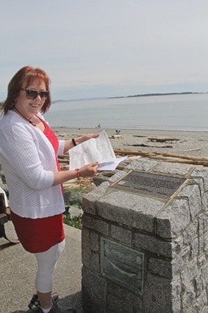
Patches of Snow, says the marker not far from the Royal Victoria Yacht Club and accessible on Beach Drive. It’s marked No. 1 on Oak Bay’s guide to First Nations monuments and it’s where Oak Bay Coun. Hazel Braithwaite and I start a walking tour.
The cairns, Braithwaite says, “are to give people a history of this land and what it was before.”
Tsartlip master carver Temoseng Charles Elliott, designed the cairns that are strategically installed at culturally significant places:
Loon Bay (Sungayka), Willows Beach (Sitchanalth), Bowker Creek (Thaywun), Turkey Head (Spewhung), Anderson Hill (The Guardian), McNeill Bay (Chikawich), Trafalgar Park lookout and Harling Point (Sahsima).
“It is very, very doable, you could (walk) it in sections too if you wanted,” Braithwaite says. For the sake of work-hours, that’s what we choose, small bits of walking augmented by vehicle. The method offers some insight on where ample parking allows a great starting point for those looking to hike or cycle a handful of the cairns.
The first on our stop is among the easy-to-miss in a small green space at Loon Bay where we stop and envision the village that existed there. It also served as a defensive site for the Lekwungen-speaking people.
“It’s easy to walk by and that’s not the point,” Braithwaite says, as we hoof it over ample sidewalks toward the next cairn. “The point is to stop and see what was here before and imagine what was here before.”
After a hop across Cattle Point and down the stairs to Esplanade, we make our second stop at Willows Beach, looking out toward Discovery Island.
Braithwaite stumbles only slightly over the word Kohweechela – which means “where there are many fish” in L’kwungen – as she gestures to what many locals call Jimmy Chicken Island, officially now labeled Mary Tod Island.
https://gvpl.ca/using-the-library/our-collection/local-history/tales-from-the-vault/jimmy-chicken
The neighbourhood is well-documented with archaeological sites where longhouses lined the shore.
“People who rebuild here use the same foundation, they don’t disturb anything,” Braithwaite says.
QR codes affixed to the cairns offer some additional information for those with a smart phone and a free app.
After breezing through a few cairns, we stop again at Anderson Hill, a place with plenty of parking and the hill itself boasts enough space to spend some time, relax and enjoy the view, while the breeze rustles Garry oak leaves.
Our final visit is to the Harling Point cairn by the Chinese Cemetery. It tells the Songhees story of of how Hayls, the Transformer, with spirit companions, Mink and Raven, came in his canoe and frightened away a seal that a harpooner was stalking. When the harpooner rebuked them, Hayls turned him to stone leaving him to protect the seals there forever.
As we approach the sparkling shoreline and look out across to Trial Island you see Hayls standing just off the rocky shore – still protecting the seals.
Pick up a guide to the monuments at municipal hall, 2167 Oak Bay Ave. where Elliott’s artwork for each cairn is also on display.
http://www.oakbaynews.com/news/286141971.html
It’s also a great starting point of the 13-kilometre tour that takes roughly five hours walking, two hours by bike or 1.5 hours by car.
cvanreeuwyk@oakbaynews.com