Well known for its flora and fauna, Uplands Park is also home to intriguing and highly visible rock formations.
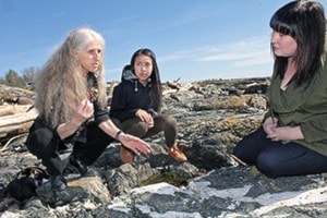
“There is also the earth under our feet and that is what we’ll look at,” said JoAnne Nelson, of the BC Geological Survey.
She and her peers will share that knowledge with the Cattle Point Seaside Geotour April 17.
They’ll share their knowledge on the bedrock formation by plate tectonic collisions, glacial pathways on the surface of the bedrock, and how the sea shapes the land by looking at the sand of Willows Beach.
“You can just see so many things here,” Nelson said. “The rocks here are the same as underly the rocky formations throughout Victoria.”
Cattle Point is one of Victoria’s stellar geological sites, showing both fascinating bedrock features, and perfectly preserved traces of ice and meltwater streams from the last glaciation.
The University of Victoria brings its geology field students to Cattle Point, a well-defined area relatively free of moss and other cover, leaving the glacial trails readily identifiable.
The Friends of Uplands Park invited the geologists help park visitors recognize key clues of the ancient and not-so-ancient history of this area.
“We’re going to try and make it simple for people,” she said. “We’re putting tools in people’s hands.”
While cameras and questions are welcome, hammers are not.
“We’re happy to answer questions … it doesn’t have to be exactly about what we’re showing,” Nelson said.
The geotour is slated for Sunday, April 17 from 2 to 4 p.m. on the Cattle Point rocky foreshore are of the park.